If you’ve decided to rent a car for your trip to Mauritius, you may be looking for the most scenic drives on the island.
The great news is that none of these routes are too lengthy, providing plenty of opportunities to stop and take in the stunning views along the way.
From tranquil coastal routes framed by turquoise waters and lush greenery to steep mountain roads boasting panoramic views of the island’s interior, here are 8 of the best scenic drives in Mauritius.

***This article may contain affiliate links, meaning each time you click through and make a purchase, I earn a small commission at no extra cost to you which helps a lot in keeping this website running. Thank you for your support :)
Read more about Mauritius:
8 Scenic Roads in Mauritius
Tip: When renting a car in Mauritius, I recommend booking through Discover Cars as they compare the rates of both local and international companies so you get the best deal. Their rates start at Rs 1,000 per day and include free cancellation.
Baie du Cap Coastal Route
Distance: 25 km
In my opinion, the most iconic and scenic road in Mauritius lies on the southwest coast, along the Baie du Cap Route.
This drive takes you along palm-fringed roads, passing by local villages and viewpoints overlooking the turquoise coastline.

To make this drive even more scenic, I recommend starting your road trip at Le Morne Beach where you can snap photos with Le Morne Brabant Mountain in the backdrop.
Next, continue to La Prairie Beach, also famous for its iconic view of Le Morne Brabant.

You can also watch seaplanes land and take off from the beach or better yet take a scenic flight above the peninsula.
You can then make your way to Macondé Viewpoint before ending in the village of Bel Ombre where you’ll have the choice between relaxing at the beach, dining at the Chateau de Bel Ombre, or hiking at Bel Ombre Nature Reserve.


If you have more time, you can keep driving to Ilot Sancho, a small island accessible by foot during low tide.
Not too far from Ilot Sancho is Riviere des Galets, the only pebble beach in Mauritius, and St Felix, a beautiful white-sand beach offering excellent snorkeling opportunities.

Central Plateau
Distance: 45 km
This scenic drive in Mauritius takes you to some of the most picturesque attractions in the central area.
Begin your trip in Curepipe with a walk around Trou aux Cerfs, a dormant volcano offering a panoramic view of the surrounding mountains.

You can then continue to Mare aux Vacoas, the largest reservoir in Mauritius.
If you’re keen, you can also do a short hike at Sophie Nature Walk located not too far away.
As you keep driving south, you’ll arrive at Grand Bassin (Ganga Talao), a crater lake surrounded by Hindu temples.

A little further away is the most scenic portion of this drive – Bois Cheri – where the road winds between rows of tea fields.
Some notable attractions along this route include Trou Kanaka (another dormant volcano) and Bois Chéri Tea Factory, where you can learn about the tea-making process and taste the local tea.

You can then head toward the Black River Gorges National Park which features some of the best hikes on Mauritius Island.
If you don’t mind the short detour, you can also visit Bassin Blanc (a small crater lake) or head directly to Alexandra Falls Viewpoint before ending at Gorges Viewpoint.


Northern Route
Distance: 62 km
The Northern Route is perfect for those who want to learn about the history of Mauritius and at the same time enjoy some of the best beaches on the island.
First off, I recommend spending around 2 to 3 hours in Port Louis.
Take a stroll around the Caudan Waterfront, snap photos with the colorful umbrellas, go souvenir shopping, or have lunch with a view.

Other places worth visiting in Port Louis include the Central Market, Citadelle Fort, Chinatown, and the Natural History Museum.
Tip: To avoid any headaches, be sure to park your car at the Caudan Waterfront. Non-covered parking costs Rs 80 for the first 4 hours.

You can then drive to Pamplemousses Botanical Garden for a peaceful stroll among the palm trees and giant water lily ponds.
If you’re traveling with kids, it’s also worth making a stop at L’Aventure du Sucre, an interactive museum where you can learn about the history of the sugarcane industry.
You can then have lunch at Chateau de Labourdonnais before heading to the beaches.

Take your pick from Trou aux Biches, Mont Choisy, Grand Baie, La Cuvette, Pereybere, and Bain Boeuf, or visit them all if you have the time and energy.
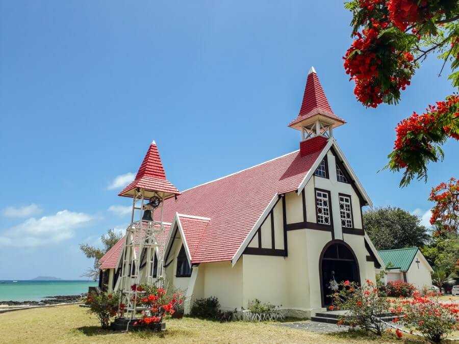
Finally, make your way to Notre Dame Auxiliatrice, the most picturesque church in Mauritius, just in time for sunset.
West Coastal Route
Distance: 50 km
The road between La Gaulette and Albion features some of the best beaches on the west coast.
Along the way, you’ll visit Flic en Flac, one of the most popular beaches in Mauritius. Bring your masks and snorkels so you can catch a glimpse of the colorful fish.

And don’t forget to check out the street food stalls for a hearty lunch of faratha with curries and local fruits for dessert.
If Flic en Flac feels too busy for you, you can instead visit Wolmar or La Preneuse Beach.
For those who love surfing, head to Tamarin Beach, which by the way, has a great view of Rempart Mountain.

Once you’re done at the beach, you can then go on a hike to Bassin Vert Waterfall.
The hike is rather short, taking you along sugarcane fields and cliffs overlooking the ocean. You can click here for details on how to visit Bassin Vert.

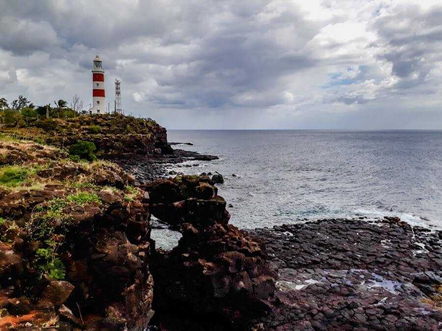
If you’re looking for a nice sunset spot to end the day, I recommend going to Albion Lighthouse.
Head down the cliffs to check out the beach caves, tide pools, and arches or simply take a walk along the trail next to the lighthouse.
Related posts:
Southeast Historic Route
Distance: 28 km
If you’ve read a bit about the history of Mauritius, you might know that the Dutch were among the first to settle in Mauritius in 1598.
They landed in the village of Grand Port which now features several monuments and museums.

Begin your scenic road trip at Pointe du Diable, a small peninsula with cannons looking out to the sea. Those were installed by the French to protect the island from British invaders.
You can then make a quick stop at Bois des Amourettes jetty to enjoy the view of Lion Mountain before heading to Grand Port to visit the Dutch First Landing monument and Frederick Hendrick Museum.

If you love hiking, you can also visit La Vallée de Ferney. There are three trails to choose from ranging from 5 to 13 km long. Entrance costs Rs 500 for tourists.
Next, drive across the Cavendish Bridge to the village of Mahebourg where you can visit more monuments and museums.
Take a walk around Mahebourg Waterfront, have lunch at one of the local restaurants, or if you’re visiting on a Monday, check out the local market.

You can then end the day with a refreshing swim at either Pointe D’Esny or Blue Bay Beach.
If you have time, go on a snorkeling trip at the Blue Bay Marine Park, which features one of the most beautiful coral reefs on the island.

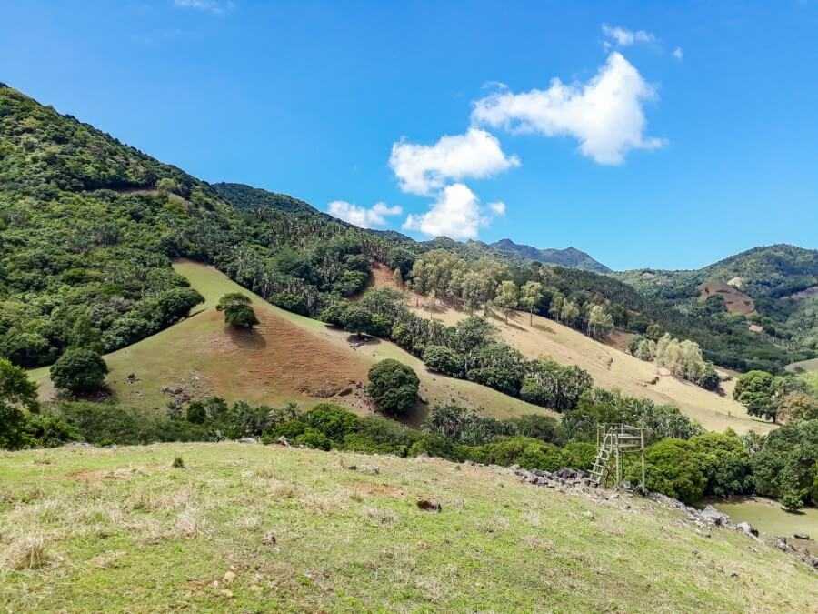
The Wild South
Distance: 42 km
The Wild South is by far one of my favorite scenic roads in Mauritius.
The reason why it’s often referred to as “The Wild South” is because this part of Mauritius is less developed compared to others.

Don’t expect to see many resorts here instead, you’ll find rugged cliffs overlooking white-sand beaches where giant waves come crashing in, gushing waterfalls, and blowholes.
Although none of the beaches along this route are suitable for swimming, they are still worth visiting for their stunning scenery.

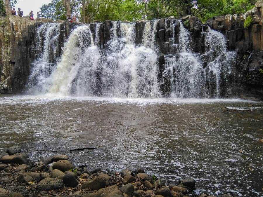
Along this route, you’ll find La Cambuse Beach, Le Bouchon Beach, Pont Naturel (a natural arch carved by the waves), Le Souffleur (a blowhole spitting water several meters high), Savinia Beach, Gris Gris Beach, La Roche Qui Pleure, Cascade Mamzelle, and Rochester Falls.

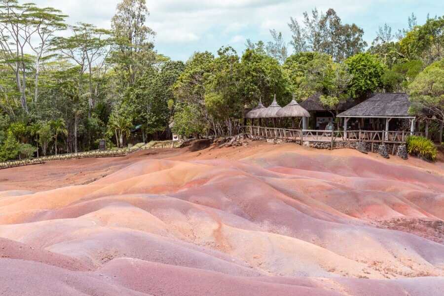
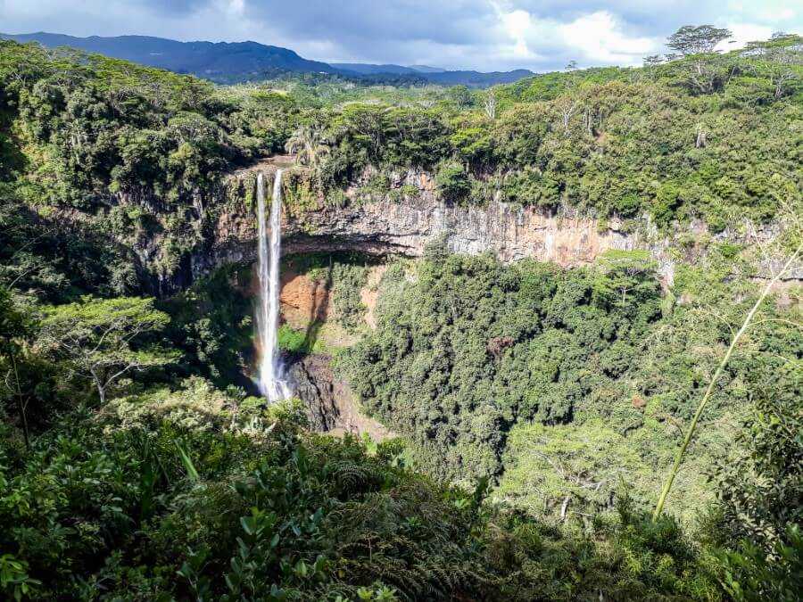
Chamarel
Distance: 8 km
This short but scenic drive along steep hairpin turns takes you to some of the most breathtaking landscapes in Mauritius.
Soak in the view from Chamarel Viewpoint, take a stroll at the Seven Colored Earth Geopark which features colorful sand dunes, a small tortoise pen, and a restaurant, admire the beautiful Chamarel Waterfall, hike at Ebony Forest, or go rum tasting at La Rhumerie de Chamarel.
Since this is a rather short drive, you can easily combine it with the Baie du Cap Coastal Route mentioned above.
Alternatively, you can also combine this trip with a visit to Gorges Viewpoint and Alexandra Falls.

Related post:
East Coast
Distance: 33 km
This beautiful coastal route runs between Roches Noires and Trou D’Eau Douce.
On this drive, you get to see the Roches Noires Caves, which are actually lava tubes. Some of these underground tunnels are interconnected and make for a short and easy hike.

Not too far away you’ll find two fresh-water holes – Basin Laver and Trou Diable.
You’ll then pass by Poste La Fayette Beach, famous for its rocky coastline, and Bras D’Eau, a small white-sand beach.

If you have time, stop by Bras D’Eau National Park for a short hike.
Next, keep driving to the village of Poste de Flacq to visit the Sagar Shiv Mandir, a small Hindu temple located on an islet that can be accessed by a bridge.

As you drive further south, you’ll come across Belle Mare Beach and Palmar Beach, both of which boast soft white sand and crystal-clear waters.


Your scenic road trip finally ends in the small village of Trou D’Eau Douce. Stroll along the palm-fringed beach or enjoy fresh seafood at the local restaurants.
Most Scenic Roads in Mauritius Map

I hope you found this guide to the most scenic drives in Mauritius helpful. If you have any questions, feel free to ask in the comments below.

1 comment
What a delightful guide to Mauritius’s most scenic drives! Thank you for highlighting these hidden gems and sharing such thoughtful recommendations.