Looking for the best hikes in Mauritius? This Mauritius hiking guide will show you a list of 29 best hiking trails and nature walks to add to your bucket list!
If you’ve been wanting to skip the crowds and explore more off the beaten path, hiking in Mauritius will allow you to do just that. Forget about lazing on the beach (for a while at least), Mauritius has an abundance of hiking trails just waiting to be explored!
While hiking in Mauritius, you’ll be able to swim in natural infinity pools, climb on top of a UNESCO World Heritage site, and chase hidden waterfalls while witnessing the most picturesque scenery!
Most of these hikes are easy, others are slightly more strenuous but nothing that an average hiker can’t handle.
I’ve personally done all of the hikes mentioned in this article in order to share only the most accurate information. So, if you’re ready for some epic adventures, here are 29 best hikes to do in Mauritius!
***This article may contain affiliate links, meaning each time you click through and make a purchase, I earn a small commission at no extra cost to you which helps a lot in keeping this website running. Thank you for your support :)
Read more about Mauritius:
- A local’s guide to Mauritius Island
- Best months to visit Mauritius Island
- Where to stay in Mauritius: Best places and top hotel recommendations
- Best beaches in Mauritius for swimming and snorkeling
- Most beautiful viewpoint in Mauritius
29 Best hiking trails in Mauritius
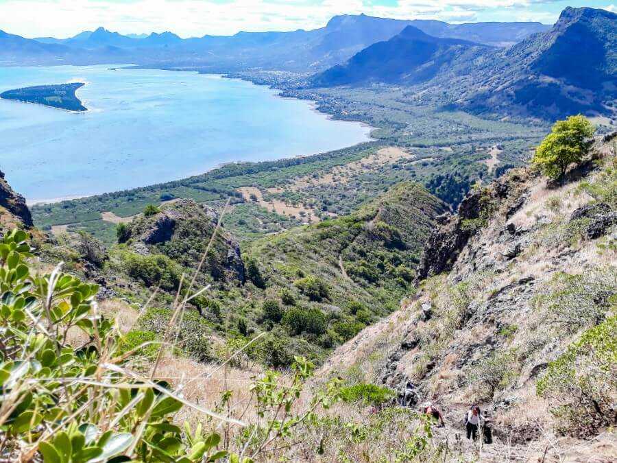
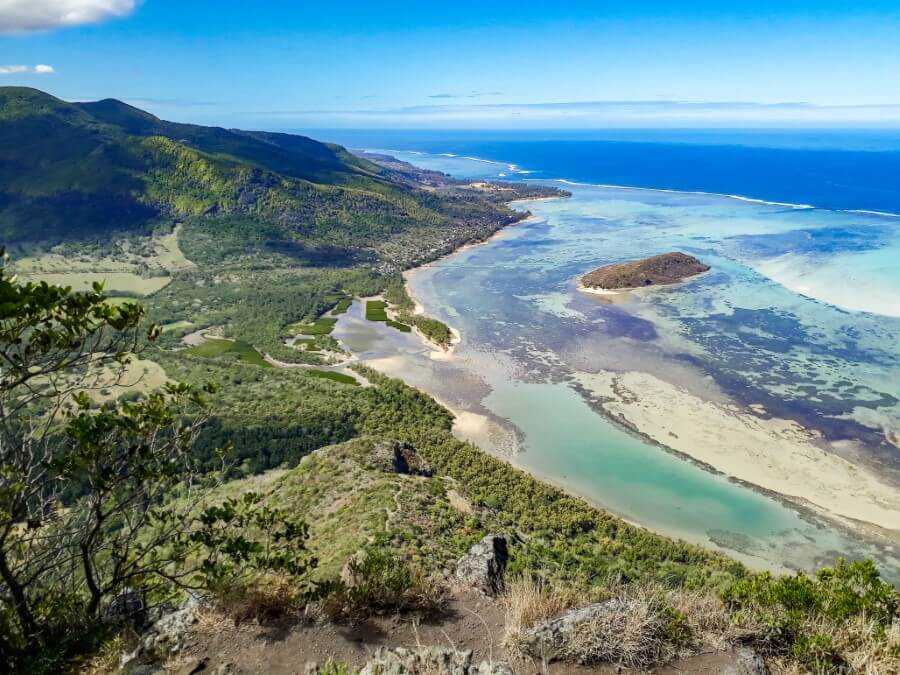
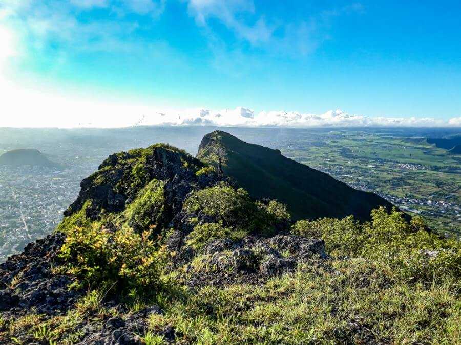
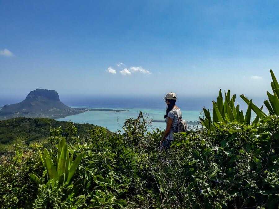
Le Morne Brabant
- Distance: 7 km round trip
- Height: 556 meters
- Difficulty: Moderate
- Total duration: 3 to 5 hours
If you have only one day to spare for a hike in Mauritius, Le Morne Brabant is an excellent choice! Leading to one of the best viewpoints in Mauritius, hiking Le Morne Brabant is the quintessential hike!
The first half of the hike is relatively easy with only a gradual incline but once you reach the first plateau, the trail becomes more challenging.
Expect to scramble over steep cliffs, but the view is definitely worth it.
If you don’t feel comfortable hiking on your own, I recommend hiring a local hiking guide.
CHECK PRICE FOR A GUIDED HIKE OF LE MORNE BRABANT
Finally, all your efforts will be rewarded with panoramic views over the mountains and the spectacular underwater waterfall. After your hike, I recommend visiting Le Morne Beach for a refreshing dip in the ocean.
Tip: The best way to get there is by hiring a car as the public bus doesn’t go directly to the trailhead.
Related post: Le Morne Brabant hiking guide
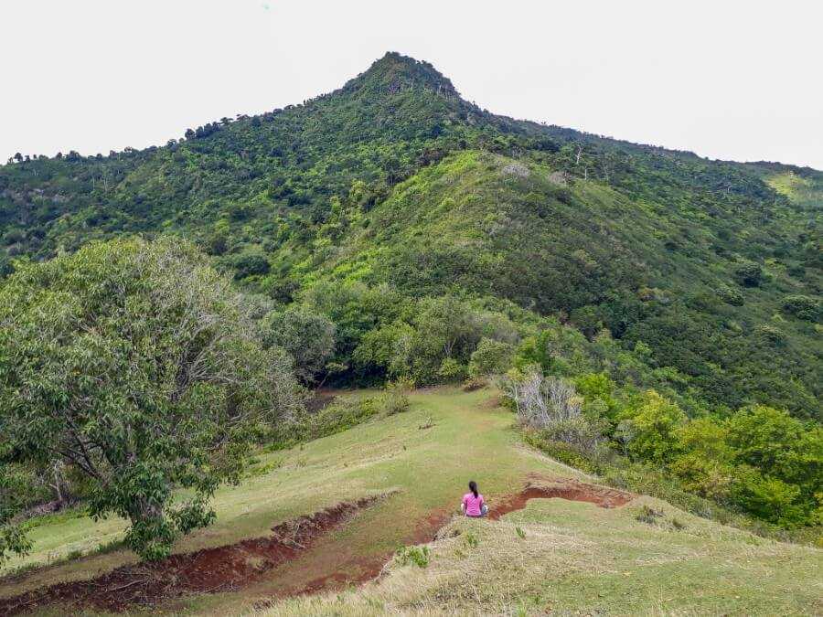
Le Pouce
- Distance: 4.5 km round trip
- Height: 812 meters
- Difficulty: Easy to Moderate
- Total duration: 2 to 3 hours
Being the third tallest mountain in Mauritius, one would think that hiking Le Pouce is quite challenging. Spoiler alert: it’s one of the easiest hikes to do in Mauritius!
Those who hike to the very top of Le Pouce mountain get to enjoy a breathtaking 360-degree view of the whole island! You can start your hike in either Port Louis or Petit Verger, the latter being easier.
The trail is easy to follow and weaves under a canopy of trees with several viewpoints along the way.
If you’re not an experienced hiker, it’s best to hire a local guide as the “thumb” section is slightly more challenging due to the steep terrain.

Related post: Ultimate guide to hiking Le Pouce Mountain
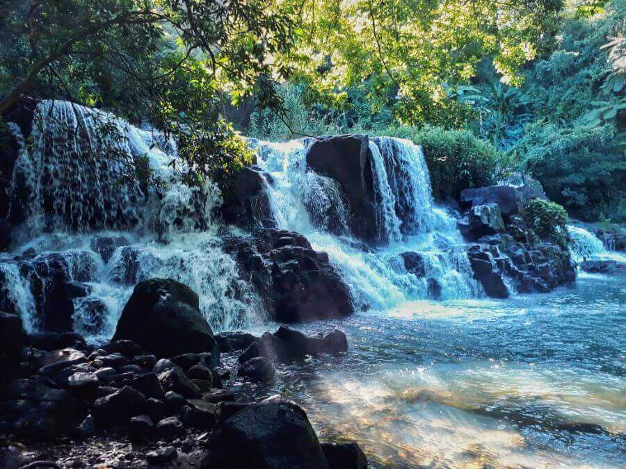
7 Cascades (Tamarind Falls)
- Distance: about 5 km
- Difficulty: Moderate
- Total Duration: 4 to 6 hours
If you’re planning on hiking in Mauritius, you absolutely cannot miss 7 Cascades (also known as Tamarind Falls)! From the name, you might think that there are only seven waterfalls but there are actually 12!
This is an adventure-packed hike coupled with gorgeous views over a lush valley. It’s not easy but so worth it! You can even walk behind one of the waterfalls and swim in the pools.
Although you can hike Tamarind Falls on your own, I highly recommend hiring a local guide if it’s your first time visiting or if you’re not too confident hiking on your own.
Having a guide will ensure your safety and prevent you from getting lost. Although there are orange markers in some places, it’s not always easy to find your way around.
CHECK PRICE FOR A GUIDED HIKE OF 7 CASCADES
Related post: How to hike 7 Cascades?
Cascade 500 Pieds
- Distance: 4 km round trip
- Difficulty: Moderate
- Total Duration: 1 to 1.5 hours
Located in the Black River Gorges National Park, Cascade 500 Pieds is one of the tallest waterfalls in Mauritius.
The hike starts at the Alexandra Falls viewpoint and involves a few river crossings but you’ll be rewarded with panoramic views and a natural infinity pool.
The path is easy to follow but gets steeper toward about halfway through, so a moderate level of fitness is required.
If you want to hike to the bottom section, I highly recommend hiring a guide as the hike becomes more strenuous.
Related post: Complete guide to visiting Cascade 500 Pieds
Alexandra Falls
- Duration: 10-15 minutes one way
- Difficulty: Moderate to strenuous
If you’re looking for a short but exciting hike in Mauritius, Alexandra Falls is for you! The trailhead is located at the Alexandra Falls viewpoint in the Black River Gorges.
The 10-minute hike to the base of the waterfall will take you through a dense forest before you finally emerge in front of the 30m waterfall.
For the exact directions on how to get to Alexandra Falls, make sure to read this guide.

Related post: Hiking to Alexandra Falls in Mauritius
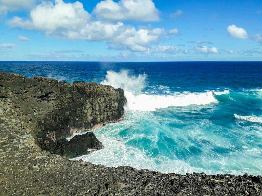
Gris Gris Beach Coastal Hike
- Distance: 5 km round trip
- Difficulty: Easy
- Total duration: 2 to 3 hours
As one of the most unique beaches in Mauritius, Gris Gris is a very popular spot situated on the south coast. The waves can get pretty rough here, making the view even more spectacular.
But beyond the beach, you’ll find hidden caves, hidden waterfalls and jaw-dropping viewpoints, making it one of the most epic hikes in Mauritius.
You can start at Gris Gris parking lot by first visiting the beach and “secret” cave. Next, make your way to “La Roche Qui Pleure” and finally end with a visit to the hidden waterfalls.
Tip: Make sure to book this 3-hour guided hike of Gris Gris beach if you want to visit with a local guide and explore all of the lesser-known spots far away from the crowds.

Related post: How to hike to the hidden spots at Gris Gris?
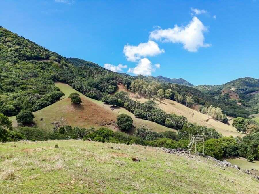
Deux Mamelles Mountain
- Distance: 2.4 km round trip
- Height: 630 meters
- Difficulty: Easy
- Total duration: 2 hours
Deux Mamelles mountain is situated in Beau Bois next to the Terre Rouge-Verdun link road.
It has two summits: west and east, the latter being the most accessible.
The mountain boasts panoramic views over Pieter Both, Le Pouce and Long Mountain and is perfect for those looking for a short and easy hike.
I only attempted the east summit since it takes less than one hour one way. I used this map from Explore Mauritius and found it to be accurate. Alternatively, you can download the maps.me app and search for “Deux Mamelles track”.
The trailhead is found along a dirt track next to the main road (exact GPS location). You can park your car here but make sure you’re not blocking the road.

The hike begins between the sugar cane field and you’ll find the mountain directly in front of you. Walk along the trail until you reach an intersection. The path straight ahead leads to the west summit while the one on the right leads to the east summit.
Turn right and keep walking until you reach a small bridge. Along the way, you’ll see a few signs showing the way to the summit.
The path is wide and well-beaten until you reach the foot of the mountain where it becomes narrower and more overgrown.
You’ll eventually find a few stone steps that lead to a viewpoint overlooking Pieter Both mountain.

On your left are two paths that go into the forest. Take the path on the far right side and keep going until you reach a large green field overlooking the motorway below.
From here, it should take about 15 minutes to reach the summit.
Note: Right before reaching the summit, you’ll find three huge boulders stacked on top of each other. Keep this in mind on your way back and once you see the boulders, keep to your right to stay on track.

Plateau Remousse Viewpoint
- Distance: 5.6 km round trip
- Difficulty: Easy
- Total duration: 1.5 to 2 hours
I actually stumbled upon this trail by mistake while hiking in the Black River Gorges National Park. I was initially planning on hiking to Macchabée viewpoint but somehow followed the trail to Plateau Remousse instead.
I’m so glad I found this little hidden gem! The viewpoint is stunning with views over the lush forests and if you look closely, you can even see the ocean from up there.
Start your hike from the Black River entrance (west side) and make your way through the forest until you reach an intersection and a sign showing the way to Macchabee trail and Plateau Remousse.
Continue straight ahead and stay on the trail until you reach a river and a little picnic area.
From there, you just need to walk across the river and then turn left. Eventually, the trail becomes steeper but it’s still accessible to all fitness levels as long as you take regular breaks in between.
You’ll then reach the first viewpoint on your right and you’ll see another path on your left.
Don’t turn left but instead, keep going straight ahead until you reach another sign. Finally, turn right to get to Plateau Remousse viewpoint.
CHECK PRICE FOR A GUIDED HIKE OF BLACK RIVER GORGES

Related post: Black River Gorges NP: Best Hiking Trails
La Tourelle du Tamarin
- Distance: About 4 km round trip
- Height: 563 meters
- Difficulty: Moderate
- Total duration: 3 to 4 hours
Another awesome hike to add to your itinerary is La Tourelle du Tamarin. Situated on the west coast, it provides a breathtaking view of Le Morne, Black River, and the Tamarin salt pans.
The hike is quite challenging in some parts but there are fixed ropes along the trail so as long as you have a moderate level of fitness and are wearing good hiking shoes, you should be fine.
Since the trail is located on private property, you’ll need authorization before doing the hike.
You can read my guide to hiking La Tourelle du Tamarin for more details, including how to get the authorization, what to expect during the hike, and other helpful tips.

Related post: Tourelle du Tamarin hiking guide
Nicolière Reservoir
- Distance: about 4 km round trip
- Difficulty: Easy
- Total duration: 1.5 to 2 hours
Another Mauritius hike worth adding to your list is the Nicolière Feeder Canal hiking trail.
The trailhead is located beside the dam spillway on the opposite side of the reservoir (click here for the exact location).

This hike is ideal for all fitness levels and you just need to follow the feeder canal for about 45 minutes to 1 hour.
Be careful though as the path can be very muddy and slippery after a rainy day.
There are also lots of mosquitos along the trail, so come prepared with mosquito repellent!

Eventually, you will arrive at a small bridge called “Pont Jamblon”.
Unfortunately, the bridge isn’t well-maintained – it’s very unsteady and the handrails only go about halfway through, which is why I don’t recommend walking across the bridge.
Instead, take the narrow path on your left which is found just a few meters from the bridge.
This will lead you down to the village of Mare D’Australia. Alternatively, you can retrace your steps back to Nicoliere Reservoir.

Lion Mountain
- Distance: 5 km round trip
- Height: 490 meters
- Difficulty: Moderate to strenuous
- Total duration: 3 to 5 hours
Hiking Lion Mountain has to be one of the most challenging hikes I’ve done yet!
While the summit sits at a mere 590 meters above sea level, getting there requires some serious scrambling and the path isn’t always clear.
I got lost a few times during this hike but was eventually rewarded with a spectacular view at the summit. If you would like to do this hike, I highly recommend hiring a guide.
You can either choose to hike to the west or east viewpoint, the latter providing the best view in my opinion.

Related post: How to hike Lion Mountain in Mauritius
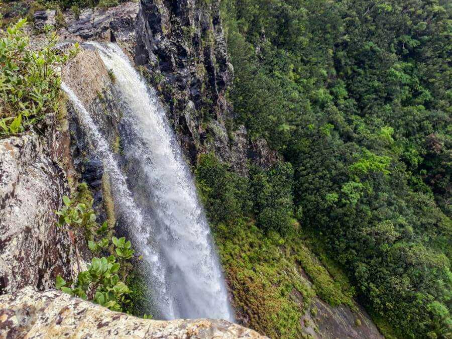
Mare aux Joncs Waterfall
- Distance: about 7 km round trip
- Difficulty: Moderate
- Total Duration: 3 to 5 hours
Mare aux Joncs is a beautiful waterfall located in the Black River Gorges. The easiest way to access the waterfall is from the west entrance.
Starting from the visitor’s center, walk deeper into the forest until you reach an intersection and a sign showing the way to Mare aux Joncs. Turn left and then follow the green and orange markers.
To be honest, the hike felt very long and boring, which is why it isn’t my favorite hiking trail in Mauritius.
Toward the end, you’ll find a big boulder on which several small stones have been stacked together. The path then becomes steeper until you finally reach the waterfall.
Tip: You can reach the top section of Mare aux Jonc Waterfall by starting your hike at Petrin Information Center. You can find more details on how to get there in this guide.

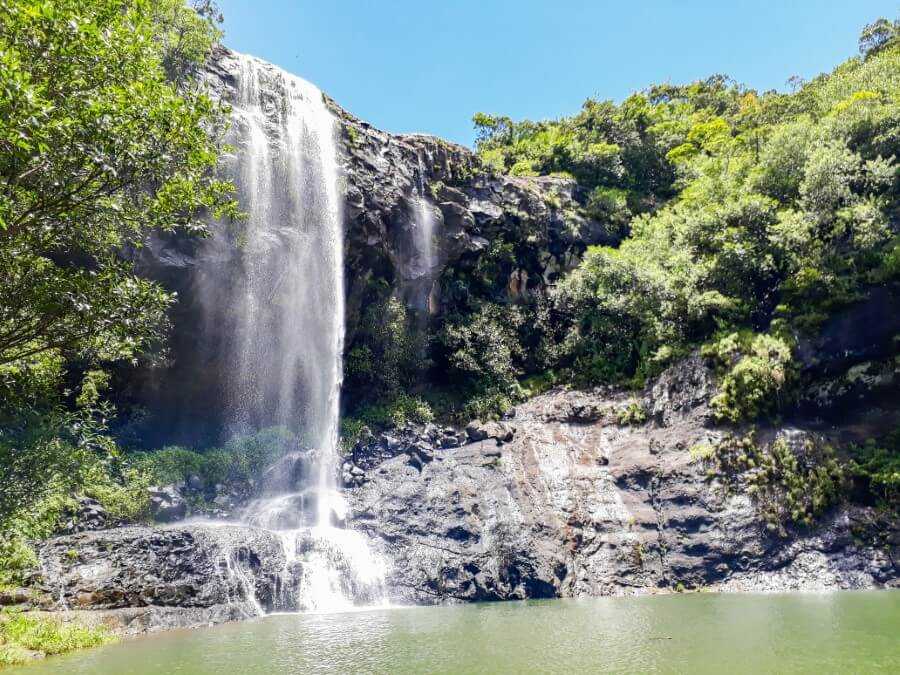
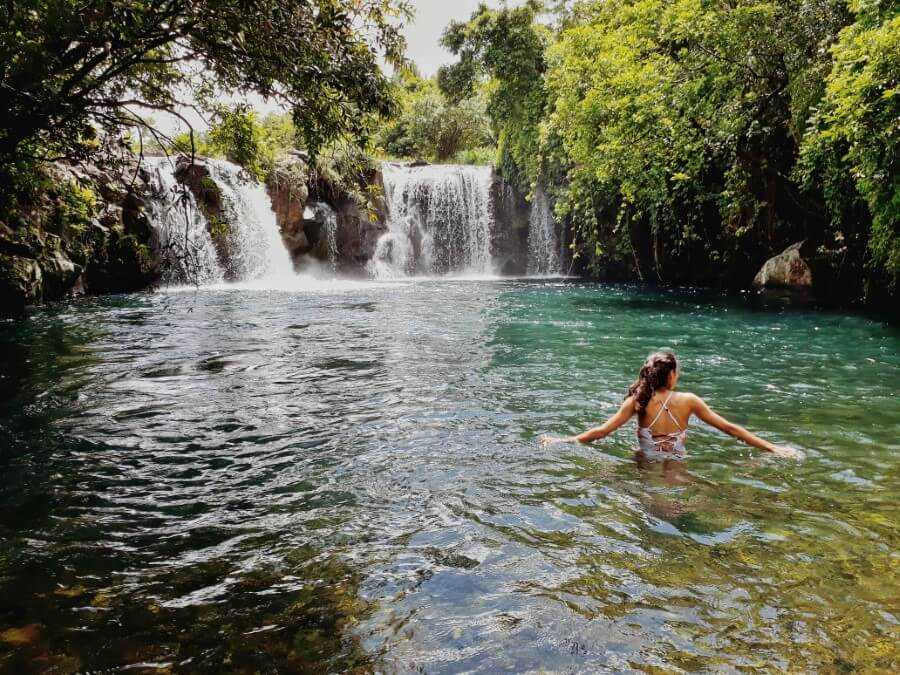
Eau Bleue Waterfalls
- Distance: 1 km
- Difficulty: Easy to moderate
- Total duration: 2 to 3 hours
Seriously though, this Mauritius hiking guide wouldn’t be complete without mentioning Eau Bleue Waterfalls!
Located in the village of Cluny, they are by far the most beautiful waterfalls in Mauritius.
The seven waterfalls are located quite close to each other, so you can visit all of them within just a few hours. What I love about Eau Bleue is the incredibly crystal-clear water.
Most people only visit the 7th waterfall, so if you want to skip the crowds, I recommend starting your hike early.
Related post: Hiking to Eau Bleue Waterfalls + Map
Cascade Leon (Exil Waterfall)
- Distance: 8 km round trip
- Difficulty: Moderate
- Total Duration: 2.5-3 hours
Cascade Leon is found in the south of Mauritius not too far from Rochester Falls.
The hike does require a moderate level of fitness since it’s quite long (4 km one way) and involves walking over some slippery rocks toward the end.
If you want more details about the hiking trail, be sure to read my guide to Cascade Leon.

Related post: Comprehensive guide to hiking Cascade Leon
Le Souffleur and Savinia Beach
- Distance: 6 km round trip
- Difficulty: Very easy
- Total duration: 1.5 to 2 hours
What most of the attractions on the south coast of Mauritius have in common are the stunning cliff views, giant waves, blowholes and epic coastal hikes.
And that’s exactly what you’ll find at Le Souffleur and Savinia Beach!
While these attractions are accessible with a 4×4, the most scenic way to get there is to hike between the sugarcane fields and forest.
It’s a flat and easy walk, taking only about 30 minutes to reach Le Souffleur and a further 10 minutes to reach Savinia Beach.
Related post: An easy hike to Le Souffleur and Savinia Beach
Piton de la Petite Rivière Noire
- Distance: 6.6 km round trip
- Height: 828 meters
- Difficulty: Moderate
- Total duration: 3 to 5 hours
Ever wondered what it’s like to stand on top of Mauritius? At 828 meters, Piton de la Petite Rivière Noire offers spectacular views over the southwest coast!
For the best experience, plan your visit on a bright sunny day or else the view might be completely blocked by thick clouds.
The trail is relatively easy to follow as there’s only one path leading to the summit.
You do need to be fit though as it takes nearly 2 hours to reach the top and the trail can be very muddy after a rainy day.

Related post: How to hike Piton de la Petite Rivière Noire
Pont Naturel
- Distance: 3 km round trip
- Difficulty: Very easy
- Total duration: 1-2 hours
Also located on the south coast of Mauritius, Pont Naturel is one of those natural attractions that will make your jaw drop!
Getting there requires a 4×4 vehicle but I decided to also turn this one into a hike.
You can start your hike from La Cambuse Beach or Le Bouchon Beach. I settled for the latter since it’s shorter and more scenic, in my opinion.
This is one of the easiest hikes on this list. You’ll walk along the beach, between sugarcane fields and mangroves and finally end at the edge of a cliff. It’s truly spectacular!
Tip: You can also book a quad bike tour of South Mauritius, including stops at Pont Naturel, La Cambuse beach, Le Bouchon beach, and Royal Palms Forest.

Related post: Hiking guide to Pont Naturel
Montagne Calebasses
- Distance: 2.5 km round trip
- Height: 650 meters
- Difficulty: Easy
- Total duration: 1.5-2 hours
Montagne Calebasses is situated in the village of Nouvelle Decouverte. The hike is very easy, taking only about 45 minutes to reach the summit.
To get there, walk along the little paved road opposite Nouvelle Decouverte Royal Road (you can use this map to find your way).
Unfortunately, there’s no parking space nearby but you can leave your car at this spot about 750 meters from the trailhead.
Once you walk past the residential area, the road will turn into a dirt track. Keep walking until you find an old metal shed on your left. You’ll also find a large green field straight ahead.

Next, turn right along a narrow path that leads slightly uphill. Once you reach the top, turn left. From there, you just have to follow a well-beaten path until you get to the summit.
From the top, you’ll get a panoramic view of Deux Mamelles, Pieter Both and Le Pouce mountain.
If you would like to extend your hike, there’s a narrow path on the right that leads to another summit.
It should take a further 5 minutes to get there and you’ll be rewarded with a nice view of Long Mountain and Nicolière Reservoir.

Corps de Garde Mountain
- Distance: About 4 km round trip
- Height: 720 meters
- Difficulty: Moderate
- Total duration: 3 to 4 hours
Located in Stanley Rose Hill, Corps de Garde is easily one of my favorite hiking trails in Mauritius.
The first time I did this hike was at sunrise and it was truly spectacular to watch the sky change color.
There isn’t much shade along the trail, so an early start is advisable. The trail is easy to follow and best for those with a moderate level of fitness.
Related post: Corps de Garde hiking guide
Macondé Peak
- Distance: 2 km round trip
- Difficulty: Easy
- Total duration: 1 hour
For a quick and easy hike in Mauritius, I recommend checking out Macondé viewpoint in the village of Baie du Cap.
The main viewpoint is located along a hairpin bend and can be accessed from the main road through a narrow set of stairs.
However, it tends to get crowded, especially during the weekend so if you want to escape the crowds, you can do a short hike to Macondé peak instead.
For more details on how to get there, make sure to read my complete guide to visiting Macondé viewpoint.
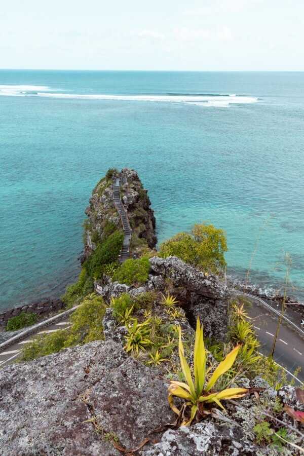
Related post: Hiking Macondé viewpoint peak
Candos Hill
- Distance: 2 km round trip
- Height: 475 meters
- Difficulty: Very easy
- Total duration: 40 minutes
If you’re looking for a very easy hike or maybe I should say a quick nature walk in Mauritius, Candos Hill is for you.
The trail leads to some great urban views with a gorgeous mountain backdrop.
The trail starts at the Sodnac Wellness Park and it takes only about 15 to 20 minutes to reach the top.

Signal Mountain
- Distance: 6 km round trip
- Height: 323 meters
- Difficulty: Easy
- Total duration: 1 to 1.5 hours
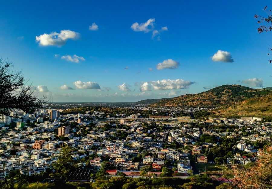
Another easy walk to do in Mauritius is Signal Mountain. Located right in the middle of Port Louis city, the walk to Signal Mountain leads to panoramic views of the city skyline and port area.
The trail is completely paved and easy to follow, so there’s no risk of getting lost. I recommend doing this walk during sunset if you want to witness the twinkling city lights.
Click here for the trailhead location.
Long Mountain
- Height: 426 meters
- Difficulty: Easy to Moderate
- Total duration: 2.5 to 3 hours
Another easy hike in Mauritius with great urban views is Long Mountain. The only downside is that the trail can be confusing at times since it isn’t well-marked.
When I did this hike a couple of years ago, I just followed the orange markers but I’m not sure if they would still be there by now.
What I would recommend is to always stay on the main trail and keep walking straight ahead until you reach the summit.
If you’re traveling by bus, you can stop at the Terre Rouge bus stop which is located on the main road. Take the little side road (click here for the exact location) that goes through a residential area.
Next, turn left at the football field and keep walking until you finally arrive at the trailhead which will be on your right (Click here for the trailhead location).

Rochester Falls
- Distance: about 500 m round trip
- Difficulty: Easy
- Total Duration: 20 minutes
Rochester Falls is among one of the most popular waterfalls in Mauritius. Since the waterfall isn’t very tall, you’ll usually find people jumping from the top.
To get there, type in “Road to Rochester Waterfalls” on Google Maps. You can park at the end of the road and it should take around 5-10 minutes to get to the waterfall.
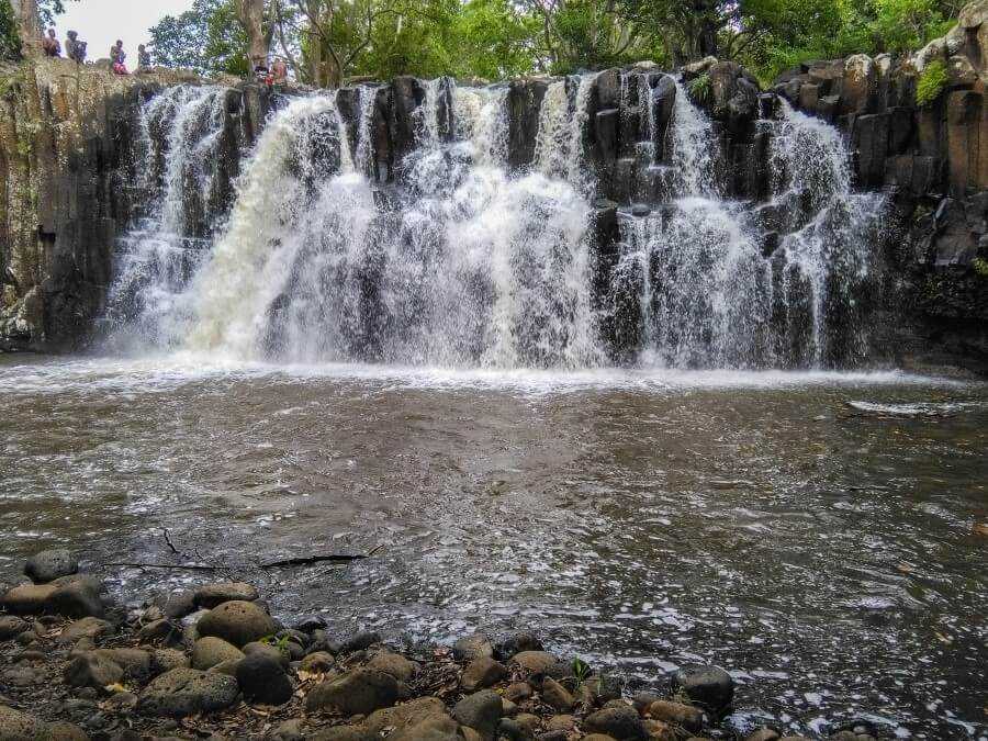
Related post: 18 Spectacular waterfalls in Mauritius
Ebony Forest
- Distance: 1 to 6 km
- Difficulty: Easy
- Total duration: 2 to 3 hours
- Entrance fee: From Rs 380
- Opening hours: 9 a.m to 5 p.m daily
Situated in Chamarel village, the Ebony Forest is a nature reserve home to rare endemic birds.
It offers spectacular views over the south coast of Mauritius and has several hiking trails perfect for the whole family.
Since Ebony Forest is a nature reserve, you’ll have to pay an entrance fee but it’s well worth it.
The fee also includes a 30-minute guided tour along the Flycatcher raised walkway where you can spot endemic birds.
CLICK HERE TO BUY TICKETS TO EBONY FOREST
There are also several other activities that you can do at Ebony Forest such as bird watching, Love Tree tour where you’ll plant your own endemic tree or the sunset tour which includes local drinks and snacks.

You can start by hiking along the Ridgeline trail which offers scenic views over the turquoise ocean and Ile aux Benitiers before ending at the Sublime viewpoint.
You can also continue to Piton Canot peak where you’ll be rewarded with a stunning 360-degree view of Le Morne Brabant, Tourelle du Tamarin, and Black River Gorges.
You can easily do this hike on your own or hire a guide. If you don’t want to hike to the Sublime viewpoint, you can opt for a Jeep tour instead.
Related post: Complete guide to Chamarel Mauritius: best things to do
Eureka Waterfalls
- Difficulty: Very easy
- Entrance fee: Rs 300
This is one of the easiest and shortest hiking trails in Mauritius. The Eureka Waterfalls are found behind the Eureka House in Moka and consist of four waterfalls.
It’s one of the very few waterfalls in Mauritius that you have to pay to visit. Honestly, they aren’t my favorites.
However, it’s a nice hike for those who just want a quick and easy stroll in nature with minimal crowds.
Related post: Guide to Eureka Waterfalls
La Vallée de Ferney
- Distance: 5, 13, and 18 km
- Difficulty: Easy to Difficult
- Total duration: 1 to 6 hours
- Entrance fee: Rs 500 for adults and Rs 250 for children (tourist price)
- Opening hours: 9 a.m to 5 p.m daily
La Vallée de Ferney is a forest and wildlife reserve located in the southeast of Mauritius. There are several trails to choose from – 5 km, 13 km, or 18 km.
The 5-km trail is easy and the perfect activity to do with kids, offering picturesque views over the valley and forests.
Bras D’Eau National Park
- Distance: 5 km round trip
- Difficulty: Very easy
- Total Duration: 2 hours
A great way to avoid the crowds is to hike at Bras D’Eau National Park. You can either start at the visitor’s center and follow the “Nature Trail” sign or from Bras D’Eau beach.
If you decide to start at the beach, walk along the main road until you find a little dirt track leading into the forest (exact GPS location).
Turn right after the old sugar mill and keep walking until you see a map of the Coq de Bois trail. You’ll come across several small lakes/wetlands (Mare Mahogany and Mare Chevrettes).
There’s also a picnic area with wooden tables and benches next to the visitor’s center and around the lakes as well.
If you have more time, you can keep walking to Mare Sarcelle, the biggest lake in the national park.
Note that the lake can also be accessed from Poste La Fayette in less than 10 minutes.

Sophie Nature Walk
- Distance: about 1 km round trip
- Difficulty: Very easy
- Total duration: 30 minutes
If you’re looking for an easy nature walk in Mauritius that’s ideal for kids, then I recommend visiting Sophie Nature Walk.
It’s not well-known among tourists, so it’s the perfect place to escape the crowds.
The park is free to visit and is open from 8 a.m to 3 p.m between Monday and Friday and from 9 a.m to 4 p.m on Saturday and Sunday.

A few tips about hiking in Mauritius
- Bring mosquito repellent, especially when hiking near rivers and waterfalls and after a rainy day.
- Always start your hike early in the morning to avoid the heat.
- Bring at least 2 Litres of water.
- In some places like Eau Bleue Waterfalls, you might come across wasps. Make sure to always stay on trail to avoid bothering their nests.
- Always watch your step and make sure to wear appropriate hiking shoes.
- Avoid hiking alone on the less popular trails. Petty thefts do happen sometimes and a lone hiker might seem like an easy target. It’s also much safer to have someone accompany you just in case you hurt yourself during the hike.
- September, October and November are considered the driest months of the year, making the weather optimal for hiking and mountain climbing.
- If you want to see the waterfalls at their most powerful, the best time to visit is from January to April. These months usually experience the highest level of rainfall as they coincide with the cyclone season.
- Avoid visiting waterfalls on a rainy day. The water level may rise very quickly without warning, making the hike dangerous.
- You can use apps like maps.me to help you navigate the trails.
- If you’re not an experienced hiker, I highly recommend hiring a guide.
Did you enjoy reading this Mauritius hiking guide? If you have any questions about the hikes, just comment down below.
More Mauritius travel guides:
- 21 Places to visit in the south of Mauritius
- 11 Places to visit in the north of Mauritius
- 21 Things to do in Flic en Flac
- Mauritius itinerary for 1 week
- 29 incredible beaches to visit in Mauritius
- Guide to traveling Mauritius on a budget
- How to visit the Black River Gorges NP?
- 18 Must-see waterfalls in Mauritius
- Top 23 things to do in Port Louis Mauritius
- Do you need to rent a car in Mauritius?
- What to expect when driving in Mauritius?

Liked this post? Pin it for later!

6 comments
Your website is a gem for anyone interested in hiking on the island. The trekking adventures you suggest are awesome and judiciously chosen. I like the advice on the trails. The directions are very helpful as most of the time we have no clue on where to start the journey. Keep it up and post new ideas on accessible spots. I will visit often to stay informed.
Best of luck
Hi Ruben. Thank you so much for the kind words! Always happy to help :)
Great Job ! Please keep doing it!
Would be nice another version with the Temples and Ashrams in Mauritius :)
Thank you Felipe :)
Well done Steph!
It sounds like you live in Mauritius, and thank you for the many tips. I need to learn and gather more details about this interesting island. Also, is there a place/blog you might recommend to find info on the various dive sites etc?
My best,
PJ
Thank you so much PJ! :) I’m really glad you’ve found my tips helpful. Indeed I live in Mauritius.
For diving sites, you can check the Mauritius Now website as they have a blog post on this topic. The north of the island has some of the best diving sites, particularly around Coin de Mire Island and Trou aux Biches/Grand Baie area.