As one of the best places for hiking in Mauritius, Black River Gorges National Park is home to over 60 km of hiking trails ranging from easy to more strenuous.
These gorgeous trails will take you through a verdant forest dotted with mountain peaks, viewpoints, and waterfalls, some of which are hidden deep into the gorge while others are easily accessible with minimum effort. It’s definitely one of the best places to visit in South Mauritius!
Covering an area of 6,574 hectares which represents about 3.5% of Mauritius Island, Black River Gorges is home to several rare endemic birds including the Echo Parakeet, Pink Pigeon and Mauritius Kestrel and over 300 species of plants and animals.
So if you’re planning to do some hiking during your trip, this guide will show you all the best hiking trails in Black River National Park.
Note: I’ve hiked all of these personally except for the Parakeet, Pilgrim and Colophane trails but plan on completing them in the near future.

***This article may contain affiliate links, meaning each time you click through and make a purchase, I earn a small commission at no extra cost to you which helps a lot in keeping this website running. Thank you for your support :)
Black River Gorges National Park Hiking Trails
There are several entrances to the national park but four main ones which I’ll go through below – Gorges Viewpoint, Alexandra Falls Viewpoint, Petrin Information Center, and Black River Visitor Center.
The staff who work at the two information centers located at Black River (exact GPS location) and Petrin (exact GPS location) can provide details about the hiking trails and have several maps of the national park.
The best way to get to Black River Gorges is to rent a car or hire a private taxi as there are no buses that serve this area. You can read my Mauritius car rental guide and my tips for driving in Mauritius.
If you’re wondering how much is the entrance fee to Black River Gorges, you’ll be pleased to know that it’s completely free to hike in the national park, making it the perfect activity for those traveling Mauritius on a budget.
Most of the trails are well-signed and color-coded, so hiring a guide isn’t necessary unless you’re not an experienced hiker or want to hike deeper into the gorge.
CHECK PRICE FOR A GUIDED HIKE OF BLACK RIVER GORGES
Note: I’ve categorized the hiking trails according to their trailhead locations for ease of reference. So, here are the best hiking trails in Black River Gorges National Park Mauritius.

Black River Gorges Viewpoint
- Facilities: parking lot, picnic area, toilet
- Hiking trails: Trochetia, Black River Peak, and Parakeet
For those who don’t intend on hiking in the Black River Gorges National Park but still want to take in the incredible views, visiting the Gorges viewpoint might prove to be a good alternative.
In my opinion, it’s one of the most spectacular viewpoints in Mauritius with several layers of mountains covered by a thick canopy of lush green forest!
It was pouring rain when I was there and a very thick fog was blocking the view.
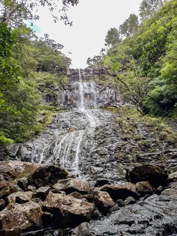
Luckily, the rain stopped a few minutes later and the fog cleared up to reveal the spectacular landscape and I was able to see a waterfall (known as Trochetia waterfall) flowing from the right.

Trochetia Trail
- Total distance covered: about 2 km
- Duration: 45 minutes
- Level: Easy to Moderate
The starting point for Trochetia trail is located on the right side of Gorges viewpoint. During my first visit, the path was completely blocked off by a group of monkeys.
After three scary encounters with monkeys in Thailand, I decided it was best to not venture there on that day.
But recently I decided to go back and luckily there were no monkeys at all! The trail is mostly flat but muddy.
You’ll find lots of guava trees along the trail so make sure to try some. Guava season is usually between March and June/July.

About 15-20 minutes into the hike, you’ll reach a river. Walk across the river to continue along Trochetia trail.
You can also choose to turn left and follow the river bed. This will lead to the top section of Trochetia waterfall.
This is the same waterfall that you can see from Gorges viewpoint. Just be very careful and avoid getting too close to the edge as the rocks are slippery.

After crossing the river, you’ll then reach an intersection.
The path on the left leads to Gollum trail which is a very strenuous hike and shouldn’t be attempted without a certified guide and proper hiking equipment.
CLICK HERE TO BOOK A GUIDED HIKE OF BLACK RIVER GORGES
On the other hand, the path on the right is easier and leads to Plaine Champagne road. If you don’t want to hike back to Gorges viewpoint, you can turn right.
If you’re looking for an alternate route to Trochetia trail, you can start at Plaine Champagne road. The trail route is marked on maps.me app, so you can use this to find your way.
Piton de la Petite Rivière Noire (Black River Peak)
- Total distance covered: 6.6 km
- Duration: 1.5-2 hours one way
- Level: Moderate
At 828 meters, the Black River Peak (also known as Piton de la Petite Rivière Noire) offers panoramic views over Le Morne Brabant, La Tourelle, and the bay of Black River.
The trailhead is located about 400 meters from the Gorges Viewpoint where you can also park your car.
The trail route is marked on both Google Maps and maps.me, making it easy to find your way.
The hike isn’t too strenuous until you get close to the summit where the path becomes steeper.
The last section is very slippery and you’ll have to use ropes to climb up, so it’s not a hike you would want to do on a rainy day.
Update: A new path has been created so you don’t have to use ropes to get to the summit. It’s also less steep, making it ideal for less experienced hikers. You can find more details by reading my guide to hiking Piton de la Petite Rivière Noire.

Related post: Black River Peak hiking trail
Parakeet Trail
- Total distance covered: 8 km
- Duration: 3 hours
- Level: Moderate to strenuous
This is a point-to-point hike that takes you from Black River Visitor Center to Plaine Champagne or the other way around.
If you start at the Black River Visitor Center, follow the signs for Parakeet trail or start about 50 meters from the Plaine Champagne Police Post.
I haven’t personally done this hike, so I don’t know the real difficulty level but I saw a sign at the Petrin Information Center that said that it’s a strenuous hike. The trail route is marked on maps.me.
Alexandra Falls Viewpoint
- Facilities: Parking lot, picnic area, toilet
- Hiking trails: Alexandra Falls, Cascade 500 Pieds, Mont Cocotte, and Bassin Blanc
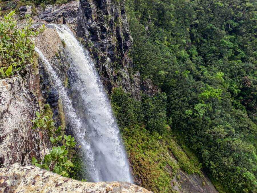
Alexandra Falls
- Duration: 10-15 minutes one way
- Level: Moderate to strenuous
Although the Alexandra Falls viewpoint might be one of the most popular places to visit at the Black River Gorges NP, most people don’t know that you can actually hike down to the base of the waterfall.
The hike down is short (about 10 minutes) but very steep and strenuous, so a guide is highly recommended for less experienced hikers.
Even if you don’t want to hike down, you can still see the top section of the waterfall from the viewpoint.
For more details on how to get there, you can read my guide to hiking Alexandra Falls here.
Related post: Complete Guide to Hiking Alexandra Falls
Cascade 500 Pieds (top section)
- Total distance covered: 4 km
- Duration: 30 minutes one way
- Level: Moderate
Dropping from 500ft (152m), Cascade 500 Pieds (also known as Cascade des Galets) is the tallest waterfall in Mauritius.
It takes only around 30-45 minutes to reach the top section of the waterfall where you’ll get an incredible view of the south coast.
You’ll also find a natural infinity pool here which is the perfect spot to cool off after a hike.
Most people end their hike at the top but if you want to go all the way down, you’ll need to hire a guide.
For more details on how to get to Cascade 500 Pieds, you can read this guide.
Related post: Hiking to Cascade 500 Pieds: Complete guide
Mont Cocotte
- Total distance covered: 4 km
- Duration: 30 minutes one way
- Level: Easy to Moderate
Mont Cocotte is one of the shortest hikes in Black River Gorges that’s suitable for beginner hikers.
The trail is easy to follow with only a steep incline as you get closer to the summit. From there, you’ll get an incredible view of the lush hills and turquoise ocean.
It takes only around 30 minutes to reach the summit from the Alexandra Falls viewpoint, making it perfect for those who are short on time.
From the Alexandra Falls viewpoint, take the path opposite the sign showing a map of the national park.
Continue straight ahead for about 20-25 minutes until you see a tree on your right that has been marked with red paint.
Go through the narrow path surrounded by tall pine trees until you reach an intersection. Turn left and continue along the trail until you reach the top.
There are two viewpoints at the top, one directly opposite the trail and another on the left.

Petrin Information Center
- Facilities: Parking lot, picnic area, toilet
- Hiking trails: Macchabee Forest Loop (including the top section of Mare aux Joncs Waterfall), Macchabee Viewpoint, Colophane, Les Mares, Brise Fer Peak, and Mare Longue
This is one of the two information centers in the Black River Gorges. You can visit the information center to refer to the maps and hiking trails starting from here.
The parking lot is quite small, so it can fill up fast during the weekend. If you don’t get a parking spot, you can leave your car across the road where you’ll find a much bigger parking lot.
There’s also a small garden with wooden tables and chairs, making it perfect for a picnic with friends and family.

Macchabee Forest Loop Trail
- Total distance covered: 8 km
- Duration: 3 hours
- Level: Moderate
This 8-km loop trail takes you along Macchabee Forest, Mare aux Joncs Waterfall, and back to Petrin Information Center.
The path is well defined with clear signs at each intersection. So, you can’t get lost as long as you stay on the trail.

From Petrin Information Center, follow the signs for Macchabee Loop. You’ll reach the first viewpoint after about 15 minutes.
There are a few other viewpoints ahead until you reach a fork in the path. You can either turn left or continue straight.


I opted to go straight and found myself walking along a relatively flat trail surrounded by tall trees.
About halfway through, there was a slight descent which gradually became steeper as I got closer to Mare aux Joncs Waterfall. It took me about 1h10 to reach the top of the waterfall.
From there, you’ll get a clear view of the mountain ridges and the river cascading down to form Mare aux Joncs waterfall.

The most challenging part will be the second half of the loop due to the very steep incline. You’ll have to scramble over roots and boulders and hold on to trees to make your way up.
After a short but intense 20-minute walk, you’ll finally emerge out of the forest and onto Macchabee trail. Turn right to get to Macchabee viewpoint (15-minute walk) or left to go back to Petrin.

Related post: 29 hikes to do in Mauritius
Macchabee Trail Viewpoint
- Total distance covered: 10 km
- Duration: 1 hour one way
- Level: Easy to Moderate (depending on where you start the hike)
This is hands down the best viewpoint in the Black River Gorges National Park!
To get to Macchabee viewpoint, you can either start from the Black River Visitor Center or Petrin Information Center.
The latter is easier since you’ll be starting your hike from a higher elevation while the hike from Black River has a much steeper incline.

From Petrin, follow the signs for Macchabee Kiosk until you reach an intersection (refer back to Macchabee Forest Loop Trail).
Turn left and continue along the trail until you reach the Macchabee Kiosk and viewpoint.
From there you get an incredible view of the gorge, Tourelle du Tamarin and Tamarin Bay. I even got the chance to spot an Echo Parakeet, one of Mauritius’ rare endemic birds!
You can continue along the path that leads down to the Black River Visitor Center or head back to Petrin.

Les Mares Trail (Paille-en-Queue Trail)
- Total distance covered: about 8 km
- Duration: 1 hour one way
- Level: Easy
Les Mares trail (Paille-en-Queue trail) is one of the least popular hikes in the gorges. The trail is flat and easy to follow, making it a great choice if you’re hiking with kids.
The trailhead is found at Petrin and you just have to follow the signs for Paille-en-Queue trail.
About ¾ of the way, you’ll reach an intersection with a sign showing the way to Le Mares roundabout and Plaine Champagne trail. Turn left to get to Les Mares roundabout (this is where the hike ends).
If you turn right, you’ll reach Plaine Champagne waterfall in about 15 minutes. Keep in mind that the path is usually muddy, so proper hiking shoes are a must!

Piton Savanne
- Total distance covered: 6 km
- Duration: 1.5 hours one way
- Level: Easy to Moderate
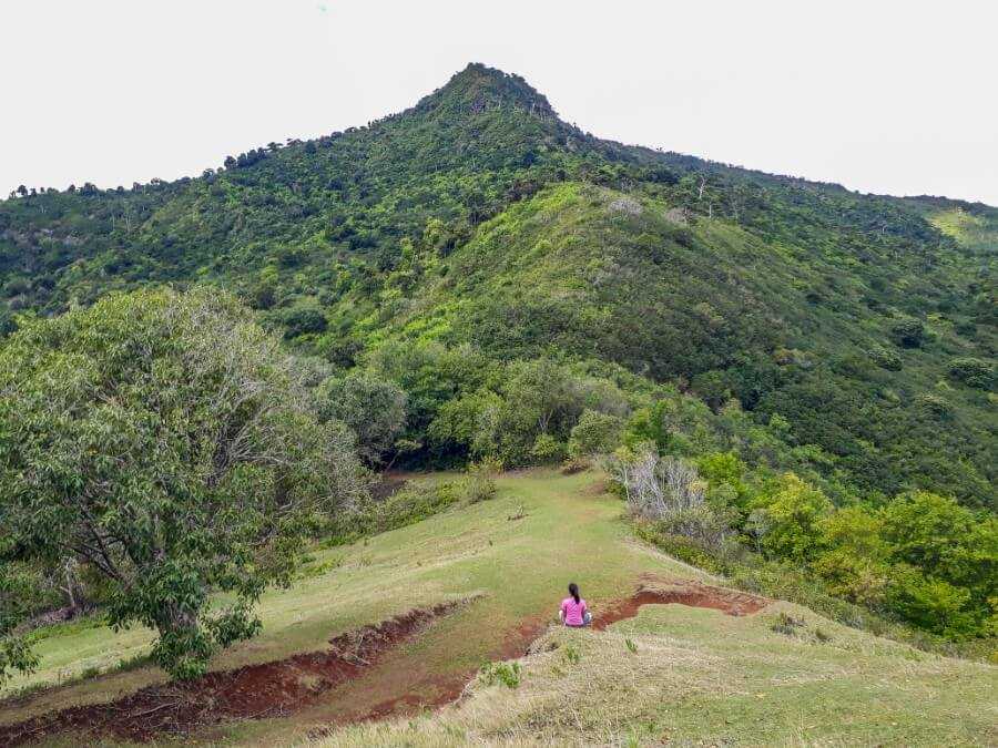
With a height of 715 meters above sea level, Piton Savanne provides the perfect vantage point over the south coast of Mauritius.
Although I’ve included this hike here, the trailhead is actually found about 3.5 km from Petrin Information Center, along the B102 road that leads toward the village of Chamouny.
While the hike isn’t too strenuous, you should expect some minor scrambling as you get close to the summit but it’s still accessible to all fitness levels.
If you’d like more information about this hike, you can read my guide to hiking Piton Savanne here.

Related post: How to get to Piton Savanne in Mauritius?
Brise Fer Mountain
- Total distance covered: 14 km
- Duration: about 2 hours one way
- Level: Moderate
Brise Fer Mountain is another great hike to add to your bucket list. The hike starts at Petrin Information center and goes through the Macchabee Forest Loop trail until it merges with Mare Longue trail.
Instead of turning left to go to the top section of Mare aux Joncs waterfall, continue ahead along Mare Longue trail until you reach an intersection with a metal gate. This is where you’ll have to turn left.
The path becomes gradually steeper until you reach the summit. For more details, I recommend downloading the maps.me app.

Mare Longue Loop Trail
- Total distance covered: 12 km
- Duration: 4 hours
- Level: Moderate
Mare Longue is a loop trail that starts from Petrin Visitor’s Center and goes through Macchabee forest to Mare Longue reservoir.
The trail is well-marked so you just need to follow the signs. The path is flat but does require a moderate level of fitness as it’s nearly 12 km long.

Read more: Best places to visit in Chamarel Mauritius
Black River Visitor Center
- Facilities: Parking lot, picnic area, toilet
- Hiking trails: Plateau Remousse viewpoint, Mare aux Joncs Waterfall (bottom section), Macchabee, Pilgrim, and Colophane
Plateau Remousse Viewpoint
- Total distance covered: 5.6 km
- Duration: 45 minutes one way
- Level: Easy to Moderate
If you’re looking for a short but scenic alternative to Macchabee trail, make sure to hike to Plateau Remousse viewpoint.
This relatively easy hike has some of the most stunning views in Mauritius!
Because it’s completely surrounded by lush forests, hills and mountains, Plateau Remousse is one of my favorite hiking trails in the Black River Gorges National Park.
The best way to get there is to start at the Black River Visitor Center.
Make your way into the forest until you reach an intersection and a sign showing the way to Macchabee trail and Plateau Remousse.
From there, follow the signs for Macchabee trail until you reach a river and a bridge.
Walk across the bridge and turn left toward the hill. The trail weaves through the forest until you reach the first viewpoint on your right.
You’ll also find another path on your left but instead of taking this one, keep walking straight ahead until you reach a sign pointing to Plateau Remousse viewpoint.
You then have to turn right to reach the viewpoint.

Mare aux Joncs Waterfall
- Total distance covered: 6 km
- Duration: 1.5-2 hours one way
- Level: Moderate
Start your hike from the Black River Visitor Center until you reach an intersection and a sign showing the way to Mare aux Joncs waterfall.
Turn left and follow the green and orange markers on the stones and trees.
The path is quite flat and covered by tall trees, providing enough shade along the way. It then becomes slightly steeper right before reaching the waterfall.
If it hasn’t been raining recently, the waterfall will most probably be a trickle.
There’s also an alternate trail that leads you to the top of the waterfall (refer to the Macchabee Forest Loop Trail above for more details).

Related post: 18 beautiful waterfalls to visit in Mauritius
Some tips before hitting the trails
- Don’t forget to bring mosquito repellent, especially if you’re hiking to the waterfalls.
- There’s no bus stop near the trail entrance, so you need to arrange for a taxi or rent a car (read my guide to driving in Mauritius here).
- Wear good hiking shoes as the trails are usually slippery.
- Since part of the national park is situated in the central part of Mauritius, the temperature tends to be cooler with a higher chance of rain, so make sure to bring a rainjacket and warm clothes.
- Bring your own food and water since there are no shops in the national park.
Where to stay near Black River Gorges
Green Cottage Chamarel
Set high atop a hill in the village of Chamarel, with great views overlooking the whole valley, Green Cottage Chamarel is for those who crave tranquility while being completely surrounded by nature.
The beautiful cottage is located about a 30-minute drive from Black River Visitor Center or 20-minute drive from Alexandra Falls Viewpoint. You can check out the full review of Green Cottage Chamarel here.
Book your stay at Green Cottage Chamarel here
Hotel Chalets Chamarel
Located in Chamarel, Hotel Chalets Chamarel features 11 well-appointed chalets that provide the most incredible views over Le Morne and the glistening turquoise ocean of the southwest coast.
The chalets are beautifully furnished and each has a private balcony where you can enjoy both the sunrise and sunset. There’s also a swimming pool on site.
The location is ideal, about a 30-minute drive from both Petrin Information Center and Black River Visitor Center.
Book your stay at Hotel Chalets Chamarel here
Hopefully, this guide inspired you to try at least one of these Black River Gorges hiking trails. If you have any questions, feel free to ask in the comments below.
Read more about hiking in Mauritius here:
- Ultimate Mauritius hiking guide
- Ultimate Mauritius waterfall guide
- Guide to visiting Alexandra Falls and viewpoint
- Guide to visiting Cascade 500 Pieds
- Guide to the underrated Exil waterfall
- Hiking Le Morne Brabant without a guide? Here’s how
- Hiking Le Pouce (“The Thumb”) mountain
- Eau Bleue Waterfalls hiking guide
- Tamarind Falls (7 Cascades) hiking guide
- Le Bouchon Beach to Pont Naturel nature walk
- How to get to Eureka Waterfalls?
- Complete guide to visiting Gris Gris Beach
- Le Souffleur and Savinia Beach in Mauritius
- How to hike La Tourelle du Tamarin
Liked this post? Pin it for later!

4 comments
Is it easy to combine some of these trails into a longer walk?
They all look quite short so would to try and do a few in the same day but finding it hard to see how they all connect to each other
Hi Jacob. Yes, you can combine them if you wish. Each hike mentioned in this blog post is categorized by location, so you can just choose which ones you want to visit. For example, you can do Alexandra Falls, Cascades 500 Pieds, and Mont Cocotte on the same day since they are close to each other. Or you can combine the Macchabee loop trail and Macchabee viewpoint hikes.
The trail to Brise Fer Mountain that you reference is marked as closed in April 2024. Not sure if there’s another way to get there but wanted to let you know. I did the Mare Long loop instead. Which was a good hike though there’s one trail marker in the ground that would steer people the wrong direction, good to keep watching for all the neon yellow-green tape on the paths. Times where it’s unclear where to go making sure you can see the tape really helps, they’ve done a good job with that.
And thanks for your posts here. I’ve followed them for a number of hikes and it’s been great
Hi Jeremy, thanks for reading my blog. I’m really glad you found it helpful :) The closed sign at Brise Fer has been there for a while (I think they forgot to remove it as I’m still seeing local guides taking people there). I will double check this with the park officers the next time I go there.
Thanks for the tip about the Mare Longue Loop. In case you have trouble finding your way around the trails, you can download the maps.me app. I’ve found it to be quite accurate.