This detailed guide to hiking Le Pouce Mountain in Mauritius includes everything you need to know from how to get there, what to expect, and essential tips!
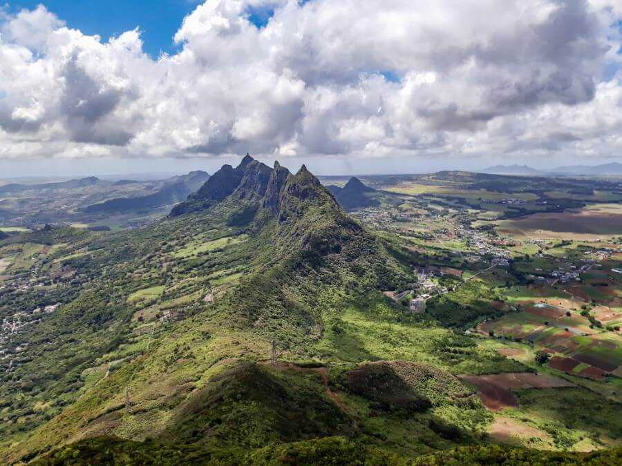
Situated in the central region of Mauritius, Le Pouce is the third tallest mountain in Mauritius standing at a height of 812 meters.
The mountain is shaped like a thumb, hence the name Le Pouce. This is one of the easiest hikes to do in Mauritius and those who climb to the summit are rewarded with a breathtaking 360-degree view of the whole island!
From one side, you can see the capital city of Port Louis with its high-rise buildings while the other boasts incredible views over the neighboring mountains flanked by sugarcane fields.
Hiking to Le Pouce Mountain is without a doubt one of the top attractions in Mauritius since the trail is easy to follow and doesn’t require too much strength (well, except for the “thumb” section).
So, keep reading if you want to get all the details on how to hike Le Pouce in Mauritius!
***This article may contain affiliate links, meaning each time you click through and make a purchase, I earn a small commission at no extra cost to you which helps a lot in keeping this website running. Thank you for your support :)
Where is Le Pouce Mountain?
Le Pouce Mountain is situated in the central region of Mauritius in the village of Petit Verger Saint Pierre. It’s located about 20 minutes from Port Louis, 50 minutes from Mahebourg or 1h 45 minutes from Le Morne.
I’ve marked the beginning of the trailhead on Google Maps which can be found here.
CHECK PRICE FOR A GUIDED HIKE OF LE POUCE MOUNTAIN

Related post: 30 best hiking trails in Mauritius
How to get to Le Pouce Mountain?
You can easily get to Le Pouce Mountain by bus from Port Louis or Saint Pierre. Bus tickets cost between Rs 17 and Rs 44 per trip (about USD 1 or less) depending on the distance covered.
Ask to be dropped off in Petit Verger along Bois Cheri Road. The bus station is found on the main road which is about 1 km from the trailhead.
Alternatively, for those planning to drive around Mauritius, you can rent a car for about Rs 1,000 per day.
CHECK CAR RENTAL RATES IN MAURITIUS HERE
If you’re coming from the village of Saint Pierre, you’ll find a little side road on your right towards the end of Bois Cheri Road (B47). The road is very narrow and at the end, you’ll find a free parking lot which can accommodate about 50 cars.
Don’t feel comfortable hiking on your own? Click here to hire a local guide!


Related post: Hiking Le Morne Brabant mountain
How to hike Le Pouce Mountain?
After parking your car, make your way toward the sugarcane fields. You find several signs along the way as well as blue and white markings on electric poles and trees.
I recommend following “La Classique du Pouce” trail as this this the shortest route to the summit.


You’ll eventually reach the sign as shown in the photo below.

Keep walking straight ahead until you find two narrow paths. You can follow either since they merge further ahead where you’ll find a boulder on which is written “Na Pa Faire Nou Montagne Vine Zot Poubelle”. So please keep the mountain clean and avoid leaving any trash behind.

From there, turn left and continue along the path sheltered by a canopy of trees. You’ll eventually reach the first viewpoint after a huge boulder shaped like a chair.
From this point, the hike becomes slightly more challenging. If it has rained recently, the trail will be very slippery so you might need to get down on your hands and knees and hold on to the trees.

Related post: Complete guide to hiking Cascade 500 Pieds
A few meters after the second viewpoint is a large rock wall painted in blue. Keep walking straight ahead until you reach the sign as shown in the photo below.


Turn right and continue along the trail for about 10-15 minutes and you’ll reach another viewpoint where you’ll get a view of several mountains in the distance, including Le Morne Brabant Mountain.
Another 10 minutes are required to reach the base of the “thumb” where you’ll find a large green field overlooking Pieter Both Mountain.
To get to the summit of Le Pouce, make your way along the path beside the green field. This is the most challenging part as the trail is very uneven and steep.
It can also be quite windy so take your time and watch out for falling rocks if there are people ahead of you.
CHECK PRICE FOR A GUIDED HIKE OF LE POUCE MOUNTAIN

Depending on how fit you are, you’ll reach the summit in about 20 minutes. The top can accommodate only about 10-15 people at a time and offers a breathtaking 360-degree view over Pieter Both Mountain, Port Louis and Plaine Wilhems.

Related post: How to visit Le Souffleur: Mauritius’ most unique natural attraction
Things to know before your hike
- The overall hike is about 3.75 km with an elevation gain of 324 meters.
- Depending on how fit you are, it should take around 45 minutes to 1 hour to reach the base of the “thumb”, and from there around 20 minutes to reach the summit. The hike down takes around 1 hour.
- I highly recommend wearing proper hiking shoes as the path toward the summit is very uneven and steep.
- You can hike Le Pouce at any time of the year but avoid hiking on a rainy day.
- There’s another hiking trail that starts from Port Louis but the hike is longer and more challenging.
- If you don’t feel comfortable hiking on your own, you can click here to hire a local guide.

Where to stay in Mauritius?
Related post: Best places to stay on Mauritius Island
I hope you found this Le Pouce Mountain hiking guide helpful! Let me know in the comments below if you have any additional questions!
More hikes in Mauritius:
- 30 beautiful hikes in Mauritius
- Ultimate guide to Eau Bleue Waterfall: the clearest water in Mauritius
- Can you hike Le Morne Brabant without a guide? Find out here!
- How to hike to 7 Cascades without a guide?
- The most scenic hike to Pont Naturel
- Eureka Falls: an essential guide
- Gris Gris Mauritius: Epic viewpoints and hidden waterfalls
- How to visit Cascade 500 Pieds without a guide?
- Guide to visiting Le Souffleur

Liked this post? Pin it for later!
