Hiking Le Morne Brabant, UNESCO World Heritage Site, ranks as one of the most iconic things to do in Mauritius! This comprehensive guide contains all the essential Le Morne Brabant hiking tips, exactly how to get to the summit, the best time to visit, and more.
With jaw-dropping views over the southern coastline of Mauritius dotted with small islands and the unique underwater waterfall, Le Morne Brabant is no doubt one of the best hikes in Mauritius!
Although challenging at times with some rock climbing along the second half of the trail, you won’t be disappointed with the stunning landscape and scenery.
If you’re planning to hike Le Morne Brabant with or without a guide, you’ll find all the information you need, including detailed directions and safety tips.
Top Pick
Best Le Morne Brabant Hiking Tour!
Book this hiking tour of Le Morne with a certified guide who will help you safely navigate the most difficult parts of the trail and take awesome photos of you! It has over 300 5-star reviews, so you can’t go wrong!
***This article may contain affiliate links, meaning each time you click through and make a purchase, I earn a small commission at no extra cost to you which helps a lot in keeping this website running. Thank you for your support :)
Read more about Mauritius:
- Top activities to do in Le Morne
- 29 awesome hikes to do in Mauritius
- 18 breathtaking waterfalls in Mauritius
Quick facts about hiking Le Morne Brabant Mauritius
- Distance: 3.5 km one way (7 km round trip)
- Height: 556 meters
- Difficulty: The initial section is easy but becomes gradually strenuous toward the summit
- Total duration: 3 to 5 hours
- When to go: Either summer or winter but NOT on a rainy day
- Opening hours: 7 a.m to 4 p.m
- What to bring: At least 2 Liters of water, snacks, and proper hiking shoes
- Location: Le Morne Village
CHECK PRICE FOR A GUIDED HIKE OF LE MORNE BRABANT

Where is Le Morne Brabant?
Le Morne Brabant is located on the southwest coast of Mauritius. It’s about a 1-hour drive from Port Louis, 1h30 from Grand Baie, or 1h45 from Belle Mare.
You can click here to find the exact location of the trailhead.
Related post: A comprehensive guide to hiking in Mauritius
How to get to Le Morne Brabant?
For those on a budget, you can choose to get to Le Morne Brabant hiking trail entrance by bus (for more info, check out this website or this one).
Bus tickets are cheap, costing between Rs 17 and Rs 47 (less than USD 1) per trip, depending on the distance covered. There’s a bus station along the main road about 1.5 km from the entrance.
Since catching a bus to the trailhead isn’t the most convenient option, I highly recommend renting a car.
Driving in Mauritius is relatively easy and the cost of renting a car is on average Rs 1,000 per day. Alternatively, you can hire a private taxi to take you there.
CHECK CAR RENTAL RATES IN MAURITIUS HERE
Along the main road, you’ll find a sign indicating that the trail entrance is 1.5 km away. You’ll then have to drive along a narrow unpaved road until you reach the parking lot.
Related post: Why you should rent a car in Mauritius
Can you hike Le Morne Brabant without a guide?
Yes, but only if you’re an experienced hiker! While Le Morne sits at a mere height of 556 meters, it’s no easy task!
Between scrambling over the rocks and the steep and exposed cliffs toward the summit, the hike can be very challenging, especially if you’re afraid of heights.
In the past, you had to be accompanied by a certified guide but this is not required anymore. I was able to do the hike without a guide and saw a few others doing the same.
But if you don’t feel comfortable hiking on your own and would prefer to be accompanied by a guide to ensure your safety, you can book a hiking tour instead.
CHECK PRICE FOR A GUIDED HIKE OF LE MORNE BRABANT
How to Hike Le Morne Brabant – Hiking Trail
From the parking lot, make your way toward the big gate. You have to sign in here before entering.
The initial section of the hike is quite easy since the trail is well-beaten with only a slight incline. The path is also shaded by trees which is a relief from the scorching sun.
Once you get past the big gate, walk along the trail until you reach an intersection with a metal gate on your left.

Go through the gate and continue along the main trail. Along the way, you’ll also find several side trails but as long as you stick to the main trail, you won’t get lost.
You’ll know you’re in the right direction when you eventually see the concrete path in the picture below.

A little further ahead, you’ll reach a fork in the path with a sign saying “Valley of the Bones Memorial Trail”. Don’t go straight ahead but instead turn right and continue along the main trail.
Eventually, you’ll arrive at another fork in the path with the first viewpoint on your right. You’ll also see two signs here – one pointing straight ahead and another to the left.
Again, don’t go straight ahead but turn left toward the uphill path where you’ll eventually see another viewpoint, this time on your left.
From there, keep walking until you arrive at an intersection. If you look to your left, you’ll get a clear view of Le Morne Brabant (see photo below).

There’s also another trail on your right that goes slightly downhill.
This one leads to a lesser-known viewpoint where you’ll get a gorgeous panoramic view of Le Morne Beach and Ilot Fourneau.
If you’re not fit enough to go all the way to the top, you can stop the hike here. The view is just as stunning and there will be far fewer people here.
Below are a few photos I recently took of the lower viewpoint.


To get to the summit, take the path on the left. After about 10-15 minutes, you’ll reach an intersection.
If you turn left, you’ll see a yellow sign warning that the hike will get harder and that you should be extremely cautious from now on.
If you’re hiking Le Morne Brabant without a guide, I only recommend going further IF you’re an experienced hiker and aren’t afraid of heights.
CHECK PRICE FOR A GUIDED HIKE OF LE MORNE BRABANT

Note: The sign also mentions that children aren’t allowed beyond this point although I’ve seen some accompanied children (perhaps around 10 years old) at the summit.
Personally, I wouldn’t recommend it for kids as the path will become very steep, almost vertical.
Before turning left toward the yellow sign, you can also turn right to get to a viewpoint overlooking Ile aux Benitiers (it takes only 1 minute to get there) – it’s a great option for those who can’t hike to the summit.

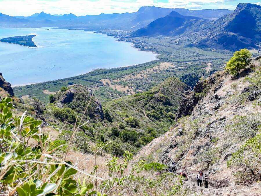
Further ahead, you’ll find a green fence. At this point, the path becomes narrower and steeper. You’ll have to scramble over the rocks and use enough arm strength to pull yourself up.
While this part can be very challenging, you just need to take your time, keep your gaze straight ahead, and avoid looking down.
Also, make sure to watch out for falling rocks and to stay hydrated as the trail is completely exposed to the sun.

After this section, the hike becomes slightly easier, and although you’ll still need to climb over the rocks, at least you know you’ve conquered the most challenging part.
It should then take a further 45 minutes to 1 hour, including regular breaks in between, to reach the summit.
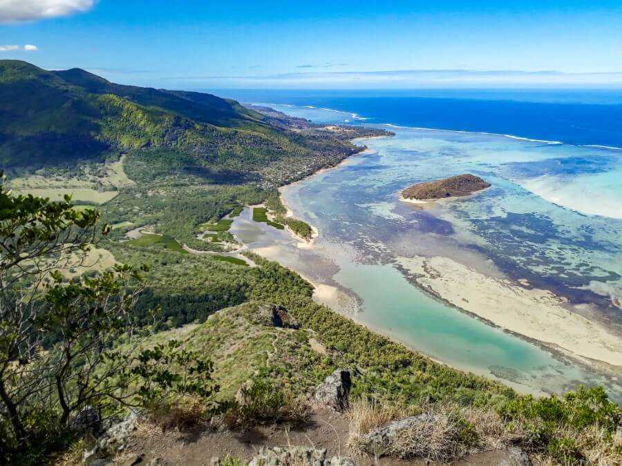
Once you get to the top, you’ll be greeted with a stunning view of the forest, mountains, and some of the most beautiful beaches in Mauritius!

From there you can admire the famous underwater waterfall, which is basically just an optical illusion created by sand being dragged down the ocean.
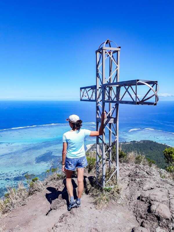
There’s also a cross at the summit to commemorate the slaves who jumped off the mountain to avoid being captured by their former masters (read more on that below).
Once you’ve enjoyed the view, make your way back by sliding down the rocks.
Getting back down might seem challenging for some but I personally found it easier and faster compared to going up.
So, if you take your time and watch out where you step, you should be fine.
Read more: How to hike Le Pouce mountain?
Is there an entrance fee?
No, hiking Le Morne Brabant is completely free!
The only things that you might have to pay for are your private driver or rental car and a local hiking guide if you don’t want to hike on your own.
CHECK PRICE FOR A GUIDED HIKE OF LE MORNE BRABANT
Best time to hike
The official opening hours of Le Morne Brabant are between 7 a.m and 4 p.m, although you can start your hike earlier.
The best time to hike to Le Morne is early in the morning as this region tends to get very hot, even in winter.
I recently hiked Le Morne Brabant again in January 2025 and it was 34 degrees Celsius. I started the hike at 7:15 a.m and it was already scorching hot, so the earlier you start, the better!
Since the second half of the trail is completely exposed to the sun, I highly recommend avoiding hiking in the middle of the day.
I also don’t recommend hiking in the dark since it would be hard to see where you step, making the hike extremely dangerous. So, use common sense to ensure your safety at all times.

Read more: Hiking to waterfalls and viewpoints at Gris Gris Beach
Duration of the hike
The round-trip hike lasts anywhere between 3 and 5 hours depending on how fit you are.
From my personal experience, it took around 1h 45 minutes to go up and 1h30 down, including regular stops in between to rest and take photos.
A Brief History of Le Morne Brabant
Back in the 19th century, runaway slaves formed small settlements inside the caves of Le Morne Brabant.
According to legend, when slavery was abolished in 1835, the Police were sent to Le Morne to inform the runaway slaves that they were now free but they jumped off the mountain thinking that they would be recaptured.
And thus, due to the mountain’s representation of the slaves’ fight for freedom, it was listed as a UNESCO World Heritage Site in 2008.
If you’re keen to learn more about the former slaves, there’s a little open-air museum at the foot of the mountain that you can visit for free.

Read more: Hiking guide to Pont Naturel
Where to stay near Le Morne Brabant?
Ma Vie La Apartments – Budget
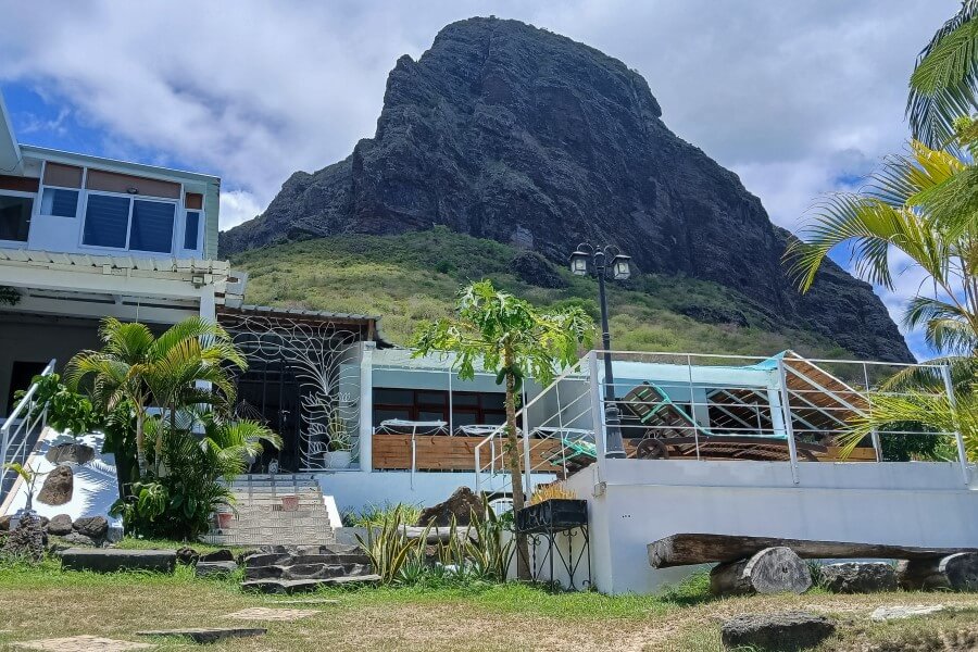
Sitting at the foot of the mountain, Ma Vie La is the perfect place to stay in Mauritius if you want to start your hike first thing in the morning.
Since it’s located on the other side of the trail entrance, you do have to drive for about 10 minutes to get to the trail entrance. Nevertheless, it’s still one of the best budget accommodations in the area.
I stayed there recently and can’t recommend it enough! The apartments boast an incredible view of the ocean on one side and Le Morne Brabant on the other.
They also have a homey vibe with clean and spacious rooms complete with a fully-equipped kitchen, private bathroom, and balcony. There’s also a common swimming pool overlooking the ocean.
Kozy Le Morne – Mid-range
Also located about a 10-minute drive from the trailhead, Kozy Le Morne offers beautiful studio apartments with a private jacuzzi as well as private pool villas overlooking the lagoon and surrounding mountains.
Paradis Beachcomber – Luxury
Paradis Beachcomber is a 5-star luxury resort featuring sea-view rooms with private balconies perfect for watching the sunset.
They have 4 restaurants serving local and international dishes, a golf course, gym, spa, and a heated pool.
CLICK HERE FOR MORE HOTELS NEAR LE MORNE
I hope you found this Le Morne Brabant hiking guide helpful. I did my best to provide the exact directions but if you have more questions, feel free to ask in the comments below.
Looking for more hikes in Mauritius? Check out these guides:
- Complete guide to hiking Le Pouce Mauritius
- Ultimate guide to hiking La Tourelle Mauritius
- How to visit Eau Bleue Waterfalls without a guide?
- Hiking guide to Sept Cascades
- Hiking guide to Leon Waterfall
- Guide to hiking to Cascade 500 Pieds
- An easy hike from Le Bouchon Beach to Pont Naturel
- All you need to know before visiting Eureka Waterfalls
- How to find the “secret” viewpoints and waterfalls at Gris Gris Mauritius?
- Exactly how to get to Le Souffleur?

Liked this post? Pin it for later!

4 comments
Strava records show that at least 10people have hiked to the top in less than 40minutes, several hundred in less than an hour.
I think some may opt out to hike this mountain when they read that it takes at least three hours – most reasonably young and regularly fit people that are used to hiking should have noe issues getting to the top and down in 1,5h on a dry day.
Thanks for a detailed description. No signs on the way up so this helped us reac the summit and down before closing time :)
You’re welcome :)
If you’re a trail runner, then yes it’s possible to get to the top in less time. But for most people, the total hike duration would be at least 3 hours including regular breaks in between to rest, enjoy the view, take photos, etc.
Thank you for this post. It gave us the confidence to do the hike with our 14yo and 16yo daughters without a guide. Yes some people were running and speed walking past us but your timing exactly matched our pace and allowed for plenty of enjoyment of the views.
Hi Samantha. Thank you, I’m really glad you found the article helpful and that you enjoyed the hike. :)